Putting the ‘Protected’ in Marine Protected Areas: How MPAs Can Be More Effective
Healthy and abundant oceans provide food, recreation, and livelihoods for people around the world. The ocean is home to over 190,000 known kinds of fish, sharks, whales, sea turtles, corals, sponges, sea grasses, and many other unique living things.1 Protecting this marine life from overfishing, pollution, habitat destruction, and climate change is key to creating the plentiful and resilient oceans that we rely on.
Creating marine protected areas (MPAs) is one way that governments and other governing bodies can safeguard the ocean. These areas often protect fisheries and habitats within their boundaries through rules and regulations unique to each site. According to the Marine Conservation Institute’s “Marine Protection Atlas,” there are over 16,600 protected areas worldwide.2 However, these areas currently only cover 8.1% of the global ocean and only 1 in 14 of these regions have full or high levels of protection.3 Successful MPAs depend on many factors, including the age of the protected area, size, location, and community buy-in. Analyzing fishing boat activity within an MPA can provide an indicator on the successes and failures of individual marine protected areas.
Fishing boat activity can be monitored in many ways, such as using location details from either automatic identification system (AIS) devices or vessel monitoring systems (VMS). These two distinct monitoring systems can use satellites and self-reporting information to record data including location, time, gear type, country flag, and ship name. Together, these systems can improve maritime safety and provide a more complete picture of fishing activity to increase compliance of laws and regulations, like the rules that safeguard MPAs.
In a report, Oceana used Global Fishing Watch’s (GFW)* AIS data to investigate 19 MPAs around the world from January 2017 to December 2020 to assess whether fishing vessels were following the rules of the protected sites. By evaluating the fishing vessels behaviors in these protected areas, Oceana identified ways to increase transparency and guard against illegal behaviors in the future.
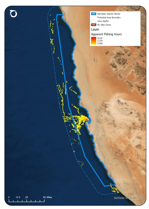
Analysts found apparent fishing activity in 16 of the 19 MPAs investigated, including one site in Namibia with about 750 hours of apparent fishing activity within its boundaries (Figure 1). Fishing with certain types of gear is not allowed within the Namibian Islands MPA. This includes gear that drags large nets behind a boat in a fishing activity known as trawling. Unfortunately, trawlers were the most common type of fishing gear that appeared to fish within the MPA. Although activity restrictions vary for each protected site, management plans and fishing rules are not always clear or publicly available.
Intentional planning and management for these MPAs is critical to ensure that the areas are successfully protected against the many threats facing our oceans. Without transparent and clear management plans, MPAs cannot reach their full potential of creating healthy and abundant oceans.
Governments, countries, and management bodies need to:
- Mandate transparency by requiring the use of automatic identification system (AIS) devices, which are tracking system devices that can improve maritime safety, combat illegal fishing, and increase compliance of laws and regulations.
- Publicly release vessel monitoring system (VMS) data to complement the AIS data and improve the surveillance of boats in areas where AIS reception varies. These are two distinct systems that are best used with one another.
- Improve monitoring and enforcement to keep fishing fleets worldwide accountable by their own countries and by those who permit them to fish within their waters.
- Require management plans to increase accessibility of clearly defined rules that can be publicly used by managers combating any illegal activity within the areas.
To see more analyses of fishing boats activity within 19 MPAs, see the full report here.
References
- Mora C, Tittensor DP, Adl S, Simpson AGB, and Worm B (2011) How Many Species Are There on Earth and in the Ocean? PLOS Biology Public Library of Science.9: e1001127. doi: 10.1371/journal.pbio.1001127
- Marine Conservation Institute: Marine Protection Atlas (n.d.) The Marine Protection Atlas. Available: https://mpatlas.org/. Accessed Oct 12, 2022.
- Marine Conservation Institute: Marine Protection Atlas (May 2022) Global Marine Fishing Protection. Available: https://mpatlas.org/zones. Accessed Oct 12, 2022.
* = Note: Global Fishing Watch uses data about a vessel’s identity, type, location, speed, direction and more that is broadcast using the Automatic Identification System (AIS) and collected via satellites and terrestrial receivers. AIS was developed for safety/collision-avoidance. Global Fishing Watch analyzes AIS data collected from vessels that our research has identified as known or possible commercial fishing vessels, and applies a fishing presence algorithm to determine “apparent fishing activity” based on changes in vessel speed and direction. The algorithm classifies each AIS broadcast data point for these vessels as either apparently fishing or not fishing and shows the former on the Global Fishing Watch fishing activity heat map. AIS data as broadcast may vary in completeness, accuracy and quality. Also, data collection by satellite or terrestrial receivers may introduce errors through missing or inaccurate data. Global Fishing Watch’s fishing presence algorithm is a best effort mathematically to identify “apparent fishing activity.” As a result, it is possible that some fishing activity is not identified as such by Global Fishing Watch; conversely, Global Fishing Watch may show apparent fishing activity where fishing is not actually taking place. For these reasons, Global Fishing Watch qualifies designations of vessel fishing activity, including synonyms of the term “fishing activity,” such as “fishing” or “fishing effort,” as “apparent,” rather than certain. Any/all Global Fishing Watch information about “apparent fishing activity” should be considered an estimate and must be relied upon solely at your own risk. Global Fishing Watch is taking steps to make sure fishing activity designations are as accurate as possible. Global Fishing Watch fishing presence algorithms are developed and tested using actual fishing event data collected by observers, combined with expert analysis of vessel movement data resulting in the manual classification of thousands of known fishing events. Global Fishing Watch also collaborates extensively with academic researchers through our research program to share fishing activity classification data and automated classification techniques.