Oceana Exposes Ships Ignoring Voluntary Speed Zone Designed to Protect Endangered Right Whales
High Speeds Put North Atlantic Right Whales at Risk, Showing Need for Mandatory Speed Limits and Enforcement
Press Release Date: March 20, 2020
Location: Washington, DC
Contact:
Megan Jordan | email: mjordan@oceana.org | tel: 202.868.4061
Oceana today released the results of an analysis finding ships ignoring a voluntary speed zone in an area south of Nantucket designed to protect endangered North Atlantic right whales, of which only about 400 remain. Between January 22 and March 6, 2020, more than 41% of the 446 ships in the area exceeded the voluntary speed limit of 10 knots, which was established by the National Oceanographic and Atmospheric Administration (NOAA) to reduce the risk of injury and death to these whales.
Studies have found that the speed of a ship is a major factor in ship-related collisions with North Atlantic right whales and that slowing ship speeds to less than 10 knots in areas where these whales may be encountered can reduce the risk of lethal collisions by 86%.
NOAA uses two different types of management tools to help protect North Atlantic right whales from the dangers of ship strikes: mandatory Seasonal Management Area (SMA) speed zones in places where whales are expected to be, and voluntary Dynamic Management Area (DMA) speed zones where whales are seen. DMAs suggest that ships avoid the area and have a voluntary speed limit of 10 knots. In contrast, SMAs require ships to slow down to 10 knots.
In November 2019, NOAA established a voluntary DMA to protect an aggregation of North Atlantic right whales south of Nantucket and Martha’s Vineyard, which is currently in effect until March 29, 2020. In recent months, this area has contained up to 60 North Atlantic right whales.
Of the 183 ships exceeding the voluntary speed limit in this DMA, Oceana found that:
- Most (92%) were large cargo and tanker ships, including one that was more than 1,100 feet long, going as fast as 18.4 knots.
- Nearly all (96%) were flagged to foreign countries such as Panama and Liberia.
- One ship reported a speed over 22 knots, more than twice the voluntary speed limit.
Conversely, Oceana found 88.4% of the ships transiting through the mandatory SMA near Block Island, Rhode Island were complying with the speed restriction.
Last year, Oceana launched a campaign in the U.S. and Canada to reduce risks to North Atlantic right whales. Oceana senior campaign manager Gib Brogan released the following statement:
“While we appreciate NOAA’s efforts, our data shows that ships simply aren’t complying with voluntary speed zones. In this case, more than 40% of the ships in the area were ignoring these voluntary speed limits and putting North Atlantic right whales in harm’s way. But when there are mandatory speed limits, ships actually slow down. NOAA must do more to protect North Atlantic right whales, including mandating that ships slow down when and where these whales are present, and increasing on-the-water enforcement to make sure they do so.”
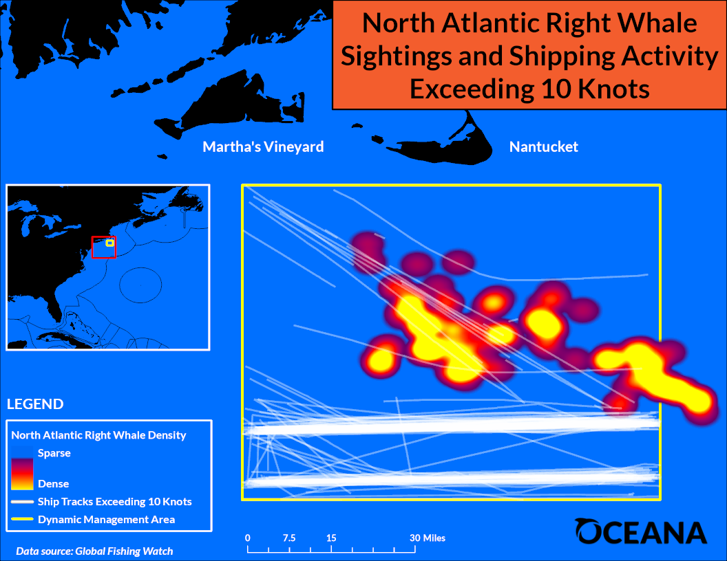
Figure: Map of vessel traffic over 10 knots in the Nantucket Dynamic Management Area (DMA) between January 22 and March 6, 2020. North Atlantic right whale density information provided by NOAA Interactive North Atlantic Right Whale Sightings Map (https://www.nefsc.noaa.gov/psb/surveys/MapperiframeWithText.html).
Oceana’s analysis used the Global Fishing Watch platform, a tool developed by Oceana in partnership with Google and Skytruth, which utilizes machine learning to interpret data from various ship tracking sources like the Automatic Identification System, to monitor ship speed and positions in North Atlantic right whale conservation areas.
Background
North Atlantic right whales were named for being the “right” whale to hunt because they were often found near shore, swim slowly and tend to float when killed. They were aggressively hunted, and their population dropped from peak estimates of up to 21,000 to perhaps fewer than 100 by the 1920s. After whaling of North Atlantic right whales was banned in 1935, their population increased to as many as 483 individuals in 2010. Unfortunately, that progress has reversed.
Collisions with ships is one of two leading causes of North Atlantic right whale injury and death. North Atlantic right whales are slow, swimming around six miles per hour, usually near the water’s surface. They are also dark in color and lack a dorsal fin, making them very difficult to spot. Studies have found that the speed of a ship is a major factor in ship-related collisions with North Atlantic right whales. At normal operating speeds, ships cannot maneuver to avoid them, and North Atlantic right whales swim too slowly to be able to move out of the way. This puts them at great risk of being struck, which can cause deadly injuries from blunt-force trauma or cuts from propellers.
Entanglement in fishing gear used to catch lobster, snow crab and bottom-dwelling fish like halibut, flounder and cod is the other leading cause of North Atlantic right whale deaths. Fishing gear from the U.S. and Canada entangles an estimated 100 North Atlantic right whales each year, and about 83% of all North Atlantic right whales have been entangled at least once. Ropes have been seen wrapped around North Atlantic right whales’ mouths, fins, tails and bodies, which slows them down, making it difficult to swim, reproduce and feed, and can cause death. The lines cut into the whales’ flesh, leading to life-threatening infections, and are so strong that they have severed fins and tails, and cut into bone.